

Jakarta, North to South: How to Read Indonesia’s Capital
At the north gate of Merdeka Square, the traffic on Jalan Medan Merdeka Utara sounds like surf, and the gold flame on top of Monas catches the light long before the street does. Look north from here and you’re facing the old Dutch port; look south and the towers of Thamrin and Sudirman stack up toward the haze. Almost everything a first-time visitor needs in Jakarta sits on that one line.
How Jakarta Is Laid Out
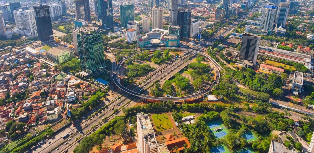
Jakarta has a reputation as a city you can’t understand, only endure from the back of a car. Spatially, it’s simpler than that. For a visitor, the city is a single north–south spine about 15 km (9 mi) long, running from the harbor at Sunda Kelapa down to Blok M, with nearly everything worth your time strung along it.
Here’s the spine from top to bottom:
- The north: Kota Tua, Glodok and Sunda Kelapa. The old Batavia core, the Chinatown that grew up just south of it, and the wooden-schooner harbor at the mouth of the Ciliwung.
- The middle: Merdeka Square. A huge green rectangle, roughly a kilometer on a side, with Monas in the center and the presidential palace, Istiqlal Mosque, the cathedral and the National Museum around its edges.
- The modern axis: Thamrin and Sudirman. One long boulevard under two names, running south from the square past the Bundaran HI roundabout into the business district, with the leafy colonial suburb of Menteng tucked just east of it.
- The south: Senayan and Blok M. The stadium complex, then the low-rise grid of Blok M, where the city starts to feel like neighborhoods again.
The land is flat delta, barely above sea level in the north, so there are no hills to plan around. What you plan around instead is heat, traffic and the gaps between sidewalks. Walk in the morning, ride in the afternoon.
Two transit lines trace this spine. The MRT North–South Line runs underground and elevated from Bundaran HI south to Lebak Bulus, 13 stations in about half an hour. TransJakarta Corridor 1, a bus rapid transit line in its own lanes, covers the full length from Blok M up to Kota. The MRT extension north toward Monas and Kota is under construction: the Monas segment is targeted for late 2027 and Kota for 2029. Until then, the bus is your link to the north.
Where to base yourself
I’d stay around Bundaran HI and the edge of Menteng, within a 10-minute walk of the roundabout. It’s the northern end of the MRT, Corridor 1 runs straight past it, and Merdeka Square is about 2 km (1.2 mi) due north along Thamrin. Dukuh Atas, the city’s big interchange and the stop for the airport train, is one MRT station south. Every day starts in the middle of the line, which halves your travel time in either direction.
Routes
Route 1: Kota Tua to the Old Harbor
Start at Jakarta Kota station, the 1929 Art Deco terminus for the KRL commuter trains, with the Kota TransJakarta stop out front (Corridor 1 from Bundaran HI takes roughly 30–45 minutes, depending on traffic). Use the pedestrian underpass at the station’s north side and you come up a few minutes’ walk from Fatahillah Square, the cobbled plaza in front of the old Batavia city hall, now the Jakarta History Museum.
From the square, walk west one block to Kali Besar, the old canal, and follow it north. The buildings along both banks are former trading houses and banks, some restored, some still waiting. The canal path is flat and paved, and in about 1 km (0.6 mi) it brings you to the Kota Intan drawbridge, a small Dutch-era bridge that’s one of the last of its kind in the city.
Keep north along Jalan Kakap and Jalan Maritim to Sunda Kelapa harbor, another 1 km or so. This is where the wooden pinisi cargo schooners still tie up in a long row, bowsprits angled over the quay. The streets here are rougher underfoot and there’s truck traffic, so stay alert. Round trip from Kota station is about 4.5 km (2.8 mi), 2.5–3 hours with stops.
Optional Glodok extension: Cross back to Kota station and head south along Jalan Pintu Besar Selatan into Glodok, Jakarta’s Chinatown. The lanes around Petak Sembilan, about 1 km (0.6 mi) from the station, hold old temples and food stalls packed tight. Add an hour.
The Jakarta History Museum and most Kota Tua museums are closed Mondays, with entry around Rp5,000.
Route 2: Around Merdeka Square
Start at the northeast corner of the square, across from Istiqlal Mosque, one of the largest mosques in Southeast Asia, which faces Jakarta Cathedral across the street. Juanda KRL station is a few minutes’ walk north if you’re arriving by train.
From there, enter the square from the north side, where the main monument entrance is, and walk the shaded paths to Monas itself. The obelisk is 132 m (433 ft) tall, with a history museum in its base and an observation deck at the top. The summit ticket was Rp24,000 for adults in early 2026, and the deck is reached by an elevator with a famously long queue on weekends.
Exit on the west side and cross Jalan Medan Merdeka Barat to the National Museum, the colonnaded building with the bronze elephant out front.
To get home, walk south out of the square and follow Jalan Thamrin straight back to Bundaran HI, about 2 km (1.2 mi) and 25 minutes on wide, mostly shaded sidewalks. The loop, including the walk back, is about 5 km (3.1 mi). Allow a half day.
Route 3: The MRT South to Blok M
6.19°S 106.82°E. Tap in at Bundaran HI station, under the roundabout with the Welcome Monument. Ride south, and for the first stretch you’re underground beneath Thamrin and Sudirman, passing Dukuh Atas, Setiabudi, Bendungan Hilir and Istora.
After Senayan the train climbs out of the tunnel and runs on a viaduct above the road. This is the best free view of the business district you’ll get: the towers fall away behind you and the city flattens into tiled roofs. Get off at Blok M about 15–20 minutes and roughly 8 km (5 mi) from where you started, for around Rp8,000.
Blok M is a low-rise grid of shophouses, malls and street food that wakes up in the late afternoon. Walk the blocks between the MRT station and the Blok M bus terminal, about 500 m (0.3 mi), and work outward from there.
For dinner, head to Gultik (short for gulai tikungan, “curry on the corner”), the cluster of curbside stalls on Jalan Mahakam, a few minutes’ walk from Blok M Square [VERIFY exact walk]. The draw is small bowls of beef curry over rice, eaten on low plastic stools along the sidewalk. It gets going after dark and runs late into the night. If you want a sit-down alternative, the streets around Jalan Melawai, nicknamed Little Tokyo, are lined with Japanese restaurants and izakaya.
For a different way home, take Corridor 1 north from the Blok M terminal. It’s slower than the MRT, but it runs at street level and you see the whole spine roll past the window. Either way, you’re back at Bundaran HI before dark.
Map Notes
- Tap a contactless Visa or Mastercard credit card at the MRT gates; card payment launched in July 2026. TransJakarta still needs a stored-value card such as JakLingko or a bank e-money card, which you can buy at larger stations and top up at convenience stores.
- TransJakarta stops sit in the middle of the road. You reach them by footbridge, not at the curb, so look up for the ramp before you try to cross.
- Dukuh Atas is the city’s interchange: MRT, KRL Sudirman station, the airport train at BNI City, the LRT and TransJakarta, linked by walkways. From Soekarno-Hatta, take the airport Skytrain to the rail station, then the train to BNI City, about 50 minutes.
- Monas, the Jakarta History Museum and most state museums close on Mondays and some public holidays. Do the MRT and Blok M route on Mondays instead.
- Walk before 10 a.m. From roughly November to March, expect afternoon downpours; plan the outdoor routes for mornings and ride the MRT after lunch.
The Honest Take
Jakarta’s reputation is mostly earned in taxis. If you try to cross it by car at 5 p.m., it will be every bit as exhausting as people say. But if you treat it as one long line and move along that line by train and bus, it gets a lot more manageable. My one real caution is Kota Tua: the square is worth seeing, but much of the district is still mid-restoration, so go for the canal and the harbor rather than expecting a polished old town. The surprise is how much of the city’s history and modern life you can trace on a single north–south line, and how much easier that makes planning. If you only have one evening, ride the MRT south to Blok M around sunset: you get the city’s towers lit up behind you on the viaduct, then a curbside bowl of curry at the end of the ride.
1 comment on “Jakarta Travel Guide: How the City Is Laid Out”