


The Quilotoa Loop is a three-day, village-to-village hike in Ecuador’s Andes that finishes on the rim of a volcanic crater lake. From Quito you take a bus to Latacunga, then local transport to Sigchos, and walk south through Isinliví and Chugchilán to Quilotoa. That’s about 40 km and nearly 1,000 m of climbing, much of it on the last day. You don’t need a guide or a tent: every night is in a village hostal.
This guide is written as a logbook. Each stage gets its numbers first, then the notes that matter on the trail.
The route in numbers
| Stage | Distance | Walking time | Sleep |
|---|---|---|---|
| Day 1: Sigchos → Isinliví | 14 km | 4–7 h | Isinliví |
| Day 2: Isinliví → Chugchilán | 12 km | 4–8 h | Chugchilán |
| Day 3: Chugchilán → Quilotoa | 14 km | 5–9 h | Quilotoa or back to Latacunga |
Stage figures are from Wikivoyage’s Quilotoa Loop page (checked November 2026). The ranges are wide because they include stops, wrong turns and altitude.
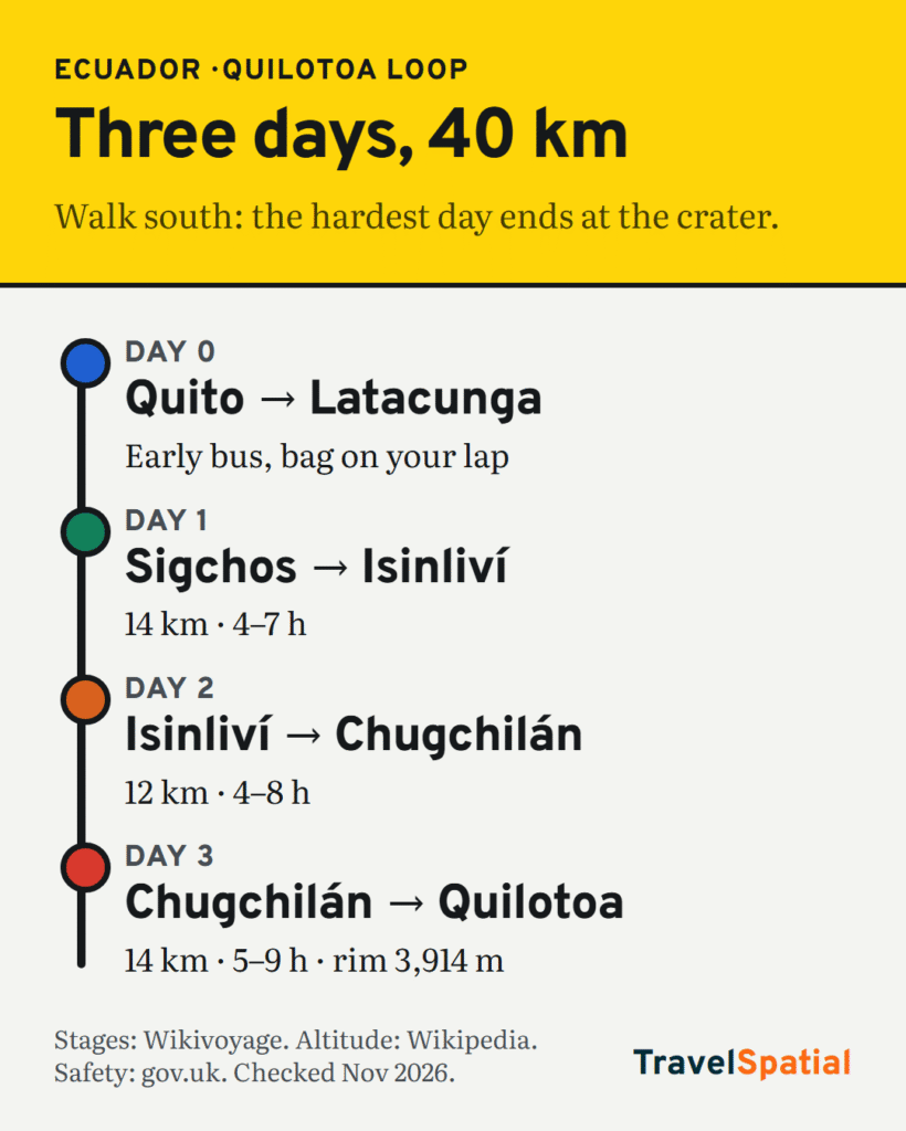
Day 0: Quito to Latacunga to Sigchos
- Bus: there are frequent buses from Quito to Latacunga. Wikivoyage advises taking an early one so you can finish each walk before dark.
- Onward: from Latacunga, take local transport to Sigchos and sleep there, or leave Latacunga early enough to start walking the same day.
- Bags: pack light for three days of walking. Many hikers leave their big bags at their Latacunga hotel; ask when you book.
- Safety: the UK government warns of robbery on long-distance buses and at bus stations, including on tourist routes. Don’t put your bag in the overhead rack or under your seat, and be wary of fake “bus inspectors” at some Quito bus stations (gov.uk).
Day 1: Sigchos to Isinliví
- 14 km · 4–7 h. The gentlest of the three days, and a good way to test how you’re coping with the altitude.
- Navigation: paths cross farmland and gullies. Download an offline map before you leave Latacunga, and ask in your hostal for that morning’s route notes.
- Sleep: Isinliví. Hostals along the loop are often all-inclusive, with dinner and breakfast in the price.
Day 2: Isinliví to Chugchilán
- 12 km · 4–8 h. Down into the Sigui (Toachi) river valley, then up the other side. The route crosses the river valley more than once over the loop.
- Pace: the climb out is the day’s real effort. Start early and stop often.
- Sleep: Chugchilán. If you’re short on time, this is also the village to cut the loop at: Wikivoyage describes an early-morning milk van between Sigchos and Chugchilán.
Day 3: Chugchilán to Quilotoa
- 14 km · 5–9 h. Wikivoyage calls this “usually the hardest day” going south, because most of the loop’s climbing comes here.
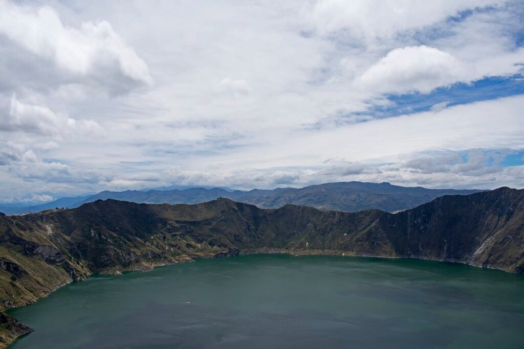
- The finish: you climb out onto the crater rim. Quilotoa’s highest point is 3,914 m, the caldera is about 3 km wide, and the lake surface lies around 3,500 m (Wikipedia).
- Extras, if you have legs left: walking down to the lake takes about 45 minutes, and the climb back up takes one to two hours. The full rim hike is about 10 km and 4–5 hours, so save it for the next morning.
- Sleep: Quilotoa village, or take an afternoon bus back to Latacunga. Wikivoyage’s older timetable shows the last bus around 17:00, so don’t rely on catching anything later.
Prefer it easier? Walk it the other way
Going north from Quilotoa to Sigchos turns the climb into a descent of about 1,000 m. You lose the big finish at the crater, but your lungs will thank you if you’ve just arrived from sea level. Either way, Quilotoa is about 1,000 m higher than Quito, so give yourself a few days in Quito first.
Pre-trail checklist
- Book ahead in high season, especially if you’ll arrive late in the day.
- Don’t hike alone, stay on established paths, and tell your hostal where you’re heading. That’s the UK government’s general hiking advice for Ecuador (gov.uk).
- Check the news before you go. Ecuador is under a state of emergency, with extra security checks and possible disruption. Heavy rain causes landslides and road closures, and Ecuador has issued an El Niño alert for 2026–27. The UK government also lists the Cotopaxi province around Latacunga as at risk of lahars from the Cotopaxi volcano.
- Cash: bring enough for hostals, buses and small entry fees.
Comparing Andes hikes? Our Inca Trail vs Salkantay guide covers Peru’s best-known options, and adventure travel for beginners covers the basics.
Log summary
Three days, about 40 km, three village beds, and a crater lake at the end. Leave Quito early, keep your bag on your lap on the bus, walk south if you want the view and north if you want the easy version.
Want more routes like this? Sign up for the TravelSpatial newsletter and we’ll send new maps as they’re published.
Sources
- Wikivoyage: Quilotoa Loop (checked November 2026)
- Wikivoyage: Laguna Quilotoa (bus times dated 2018)
- Wikipedia: Quilotoa
- UK FCDO: Ecuador safety and security (checked November 2026)
Photo credits
- Panorama quilotoa crater lake ecuador by Annom, Public domain, via Wikimedia Commons
- Quilotoa Laguna Quilotoa seen from Mirador Cristal 1 by Ymblanter, CC BY-SA 4.0, via Wikimedia Commons
The infographic is original to TravelSpatial. Photos are used under the licences linked above.

1 comment on “The Quilotoa Loop From Quito by Bus: A 3-Day Itinerary”